
Terminology
Under the hood ORBAT Mapper uses a data model loosely inspired by the Military Scenario Definition Language (MSDL). In this section we will go through some terminology you will encounter while building a scenario.
Sides and groups
A scenario consists of units organized into sides and groups. A side typically represents a nation or coalition. In a WWII scenario the sides would typically be Allied forces and Axis forces.
For each side you can specify a standard identity / affiliation. The standard identity determines the color and shape of the unit icons. The most commonly used ones are friend, neutral and hostile:
Friend
Neutral
Hostile
You can also select custom colors. This is useful in cases when you do not want to label a side as hostile or want to distinguish different nations by symbol color.
Each side consists of one or more groups of units. A group is just a way to organize your units. They can for instance represent branches (army, navy, air-force, etc.), a task force, a battlefront, etc. You can also choose not to use groups and place units directly under a side.
A side/group consists of one or more unit hierarchies. The topmost unit in a hierarchy is called a root unit.
Units
A unit is the basic building block of a scenario. It represents a military unit, such as a platoon, company, battalion,but it can also be used to represent infrastructure, equipment, vehicles, etc.
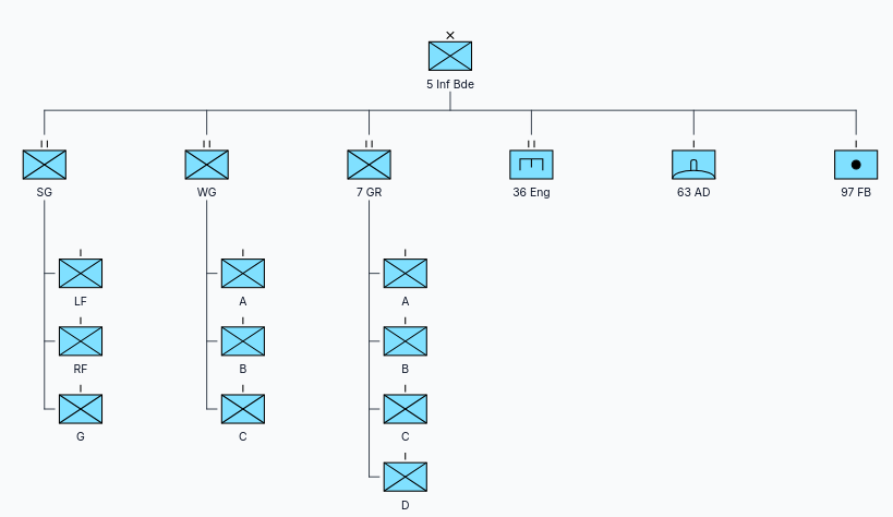
Units are organized hierarchically in a tree structure:
Each unit has a set of attributes. The most commonly used attributes include:
- name
- symbol/icon
- location
Additional attributes can be assigned to units. Examples of these are:
- description
- image
- url
- symbol modifiers
- average speed
- maximum speed
Unit state
In ORBAT Mapper, the state of a unit refers to the current values of its attributes, which can change over time. For instance, a unit's location updates as it moves, and its symbol may change if it sustains damage or is destroyed. While ORBAT Mapper is not a simulation tool, it can track changes in some unit attributes as the scenario unfolds.
Table of Organization and Equipment (TO&E)
A military unit is composed of personnel and equipment. This composition is often referred to as Table of Organization and Equipment (TO&E). The TO&E outlines the structure, roles, and responsibilities of personnel within the unit and specifies the types and quantities of its equipment.
ORBAT mapper has basic support for representing TO&E-data.
Map layers and features
The map is an important part of a scenario. A scenario map consists of multiple layers. The base layer is drawn first an on top of that you can add raster map layers and then feature layers.
A raster map layer consists of one or more raster images. Typical raster map sources are aerial photos and scanned maps. Feature layers consists of one or more features. A feature is a styled point, line or polygon on the map.